THE HEART OF THE CORAL TRIANGLE
The Raja Ampat (Four Kings) Islands lie just off the Bird's Head of New Guinea in the far western Pacific Ocean. Together these islands form the richest reef ecosystem on the planet at the heart of the coral triangle.

There the bright blue waters of the coastal fringe are teeming with over three quarters of the world’s coral species, alongside thousands of species of fish, sea turtles, rays, sharks, dugongs, and dolphins.
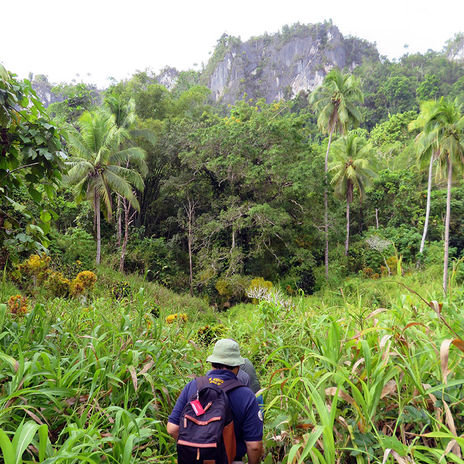
The densely rainforested island interiors are home to a vast array of marsupial tree dwellers such as cuscus along with large monitor lizards, snakes, hornbills, cassowaries, parrots, and endemic bird-of-paradise.
The natural beauty of this archipelago has long been recognized.
In 1860, Alfred Russel Wallace, the father of biogeography and
co-discoverer of the theory of evolution by natural selection, explored Raja Ampat for six weeks on the hunt for zoological specimens, describing Kabui Bay in northern Raja Ampat:
“Th[e] gulf was studded along its shores with numbers of rocky islets, mostly mushroom shaped, from the water having worn away the lower part of the soluble coralline limestone, leaving them overhanging from ten to twenty feet. Every islet was covered with strange-looking shrubs and trees, and was generally crowned by lofty and elegant palms, which also studded the ridges of the mountainous shores, forming one of the most singular and picturesque landscapes I have ever seen.”
— The Malay Archipelago

Limestone karst in Kabui Bay, southern Waigeo Island, as A.R. Wallace would have seen it in 1860.
Footage of the Raja Ampat environment.
Human culture in Raja Ampat is just as vibrant. The islands are inhabited by around 50,000 individuals, who speak eight distinct languages all within the Austronesian language family. Until quite recently most of these groups made their livelihoods by harvesting their traditional tree crop, the sago palm, alongside hunting wild game, fishing, and producing items such as pottery for exchange around the island group. From early explorers’ written records, and the islanders’ own oral histories, it is clear that this area has for a long time been a melting pot of people, ideas, and material culture, linking the societies of Island Southeast Asia in the west and New Guinea further east.


AN ARCHAEOLOGICAL ENIGMA
But archaeologists know almost nothing about the people that lived on these rich and diverse equatorial islands in the deep past, before the written record.
Who were these ancient people at the gateway between Asia and the Pacific?
PATHWAYS TO THE PACIFIC
What we do know is that some populations of our own species, Homo sapiens, left Africa and moved through Asia into the Pacific sometime before 65,000 years ago. This remarkable human journey took place during the Ice Ages, when both New Guinea and Australia were connected together by a land bridge forming the continent that archaeologists call Sahul. Similarly, the southernmost of the Raja Ampat Islands were connected to northwest Sahul due to lower Ice Age sea levels, while the northern half was separated from Sahul by a short water crossing of only 5 km.

Probable Ice Age migration pathways from Southeast Asia to New Guinea, proposed by anthropologist Joseph Birdsell (1977)
Recent computer modelling studies have shown that the Raja Ampat Islands are the most likely stepping stones that Stone Age seafarers would have landed on their journey through Island Southeast Asia
What behaviours underpinned this remarkable journey?
How did these people adapt their way of life to living in these island worlds, thick with rainforest and coral reefs?
And how did later Neolithic settlers interact with established populations and reshape the environment in their own way?
PATHWAYS TO THE PACIFIC
What we do know is that some populations of our own species, Homo sapiens, left Africa and moved through Asia into the Pacific sometime before 65,000 years ago. This remarkable human journey took place during the Ice Ages, when both New Guinea and Australia were connected together by a land bridge forming the continent that archaeologists call Sahul. Similarly, the southernmost of the Raja Ampat Islands were connected to northwest Sahul due to lower Ice Age sea levels, while the northern half was separated from Sahul by a short water crossing of only 5 km.

Sea level around 65,000 years ago
Sea level at present day
Archaeologists don’t yet know which route humans took to enter Sahul or which adaptive behaviours enabled this feat, but recent computer modeling studies have allowed some researchers to hypothesise that the Raja Ampat Islands represent the most likely landing sites for Stone Age seafarers when they arrived in Sahul for the first time.
Other computer simulations suggest that this colonisation was deliberate and involved hundreds of individuals who planned their journeys, and deliberately navigated small boats or rafts from the islands of Southeast Asia to reach continental Sahul.

Probable Ice Age migration pathways from Southeast Asia to Sahul, originally proposed by anthropologist Joseph Birdsell (1977)
The Raja Ampat Archaeological Project is starting to test these hypotheses and unlock the dynamics of ancient human migration and behaviour in this remarkable ecological zone. The project is asking questions like ‘what impact did early humans have on these peculiar environments?’ and ‘how did the first Raja Ampat Islanders adapt their social systems, technologies, and subsistence to life in this island world, thick with tropical rainforests and coral reefs?’
There are also hints from historical linguistic reconstructions that later in time, Neolithic settlers moved through the area bringing with them pottery making traditions and the Austronesian languages which are exclusively spoken in the islands today. Descendants of these settlers would later go on to venture out into the remote Pacific islands for the first time after 3000 years ago, settling the largest ocean on earth as far as Rapa Nui (Easter Island), Hawai’i, and Aotearoa/New Zealand. So how did different populations of Neolithic newcomers interact with established populations in Raja Ampat and reshape the environment and society in their own way?

DIGGING BACK THROUGH TIME
To answer these questions, the team set out for several months of archaeological reconnaissance survey and excavation on Waigeo and Gam, the largest of the Raja Ampat Islands. These islands are dotted with small fishing villages along the coast and around the large saltwater Mayalibit Bay which almost cuts Waigeo Island in two. Today, Gam is separated from Waigeo by a hidden waterway only a few metres across, known as The Passage, but in the Ice Ages the two islands would have been connected together.
In 2018 and 2019, with the help of local guides, fishermen, and hunters the archaeologists were able to locate and record over 150 previously unknown archaeological sites.
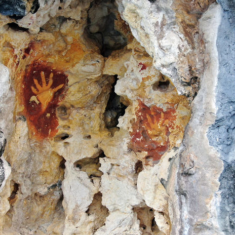
The archaeological sites included rock paintings, historical villages from the Dutch colonial period, burial caves and shrines, World War II relics, scatters of ancient pottery and stone tools, places relating to local oral traditions and myths, large cave and rockshelter sites, and middens of shellfish indicating the location of early villages.
“The chief food of the people was evidently shell-fish, since great heaps of the shells had accumulated in the shallow water between the houses and the land, forming a regular ‘kitchen-midden’ for the exploration of some future archaeologist.”
— The Malay Archipelago
Watch how the team travels to the archaeological sites around Waigeo each day.
As the team prepared for excavations, their focus turned to the enormous limestone caves nestled within the rainforest, often up sheer 30 metre cliff faces, and now home to colonies of hundreds of large fruit bats. These sites were considered likely to contain traces of the earliest settlement of the islands, when hunter gatherer peoples used them as temporary shelters.
And so the archaeologists worked alongside members of the local community to excavate three caves around Waigeo and Gam Islands, digging down two and a half metres deep in some areas, to uncover a record of what human settlement was like in the deep past.

The excavators were systematic, meticulously removing layer by layer, centimetre by centimetre, increasingly digging back deeper in time. The archaeological material was carefully mapped in three dimensions and the sediment was sieved through small mesh so that even the smallest artefacts and bones would not be missed. All of this archaeological material was bagged and recorded meaning the precise location and context can be interpreted, slowly piecing together a picture of the processes of site formation.
Click above to see one of the cave sites in 360 degrees
The digging revealed the complex stratigraphic layers of human activity. These included hearth and midden features where humans had been cooking and processing food, along with artefact remains where people had produced and discarded their everyday tools.
Watch the team at work excavating inside the caves.
In the very top of the excavations, pottery fragments have been radiocarbon dated to the Neolithic period, and show similarities with other potting traditions further west in northern New Guinea and Island Southeast Asia. Deeper down, many of the older tools are stone flakes used for cutting and scraping activities, and ‘bone points,’ perhaps used as needles for threading and perforating natural fibers. Bone points are known from other sites across Southeast Asia and western New Guinea, dating from around 45,000 years ago through to around the beginning of the Neolithic, 3000 years ago. In Africa and Europe the innovation of composite bone technologies are seen as markers of the emergence of increased cognitive flexibility within our species.

As the research progresses, both in the field and in the laboratory, the team is beginning to provide answers to some of their questions. These include which species of animals the Raja Ampat Islanders were hunting and foraging for, how they were making their stone and bone artefacts, where they were moving around the landscape and collecting raw materials from, when pottery making groups arrived in the area, and how these different populations adapted their ways of life to thrive in this unique rainforested archipelago.
In beginning to unearth the deep past of West Papua, we can contribute a vivid understanding of the inspiring human story of the first Pacific Islanders and their descendant populations who live in the area today.
Photographs and video: Tristan Russell and Dylan Gaffney
Video production: Ellena Zellhuber-McMillan
Music: Arnold, Laura. 2017. The documentation of Ambel, an Austronesian language of Eastern Indonesia. London: SOAS, Endangered Languages Archive. URL: http://elar.soas.ac.uk/deposit/0377.
-
Video 1: Flute Music by Abraham Fiay, Korneles Fiay Tokoadat, Mariam Rumbewas, Yahia Fiay, Dolfina, Fiay, and Sennerin Kein.
-
Video 2: Guitar music by Obet Nego Kein, Marius Kein, Mesa Kein, Regina Kein, Guter, Surawi, Zeh Galan, Robert, Wakaf
-
Video 3: Sago pounding song by Frans Wakaf
Text , illustration, and web design: Dylan Gaffney
Translation editor: Yulio Ray
Thanks to: Christoph Parsch for clarifying animal species identifications.


